Multi-day treks in Switzerland: Haute Route, Via Alpina, and Tour du Mont Blanc
What is the best multi-day trek in Switzerland?
The Walker's Haute Route from Chamonix to Zermatt (14 stages, 200km) is widely considered the finest long-distance walk in the Alps. The Via Alpina traverses Switzerland from Liechtenstein to Geneva across 20 stages. Both require solid fitness and mountain experience.
Multi-day trekking in Switzerland: what to expect
Switzerland’s high-alpine terrain creates the conditions for some of the world’s finest long-distance mountain walking. The Haute Route, Via Alpina, and Tour du Mont Blanc are the three most celebrated multi-day routes, each traversing mountain landscapes that exceed most hikers’ expectations for sustained visual drama. These are serious undertakings: multiple-day routes across high terrain requiring physical fitness, mountain weather awareness, and logistical planning. But they are also well-supported, with mountain huts at regular intervals, SAC (Swiss Alpine Club) shelters offering basic accommodation, and valley accommodation options where routes descend to lower ground.
This guide covers the essential information for planning each major route, including stage lengths, difficulty ratings, hut booking requirements, and the best sections for those who want to sample a portion without committing to the full distance.
Walker’s Haute Route: Chamonix to Zermatt
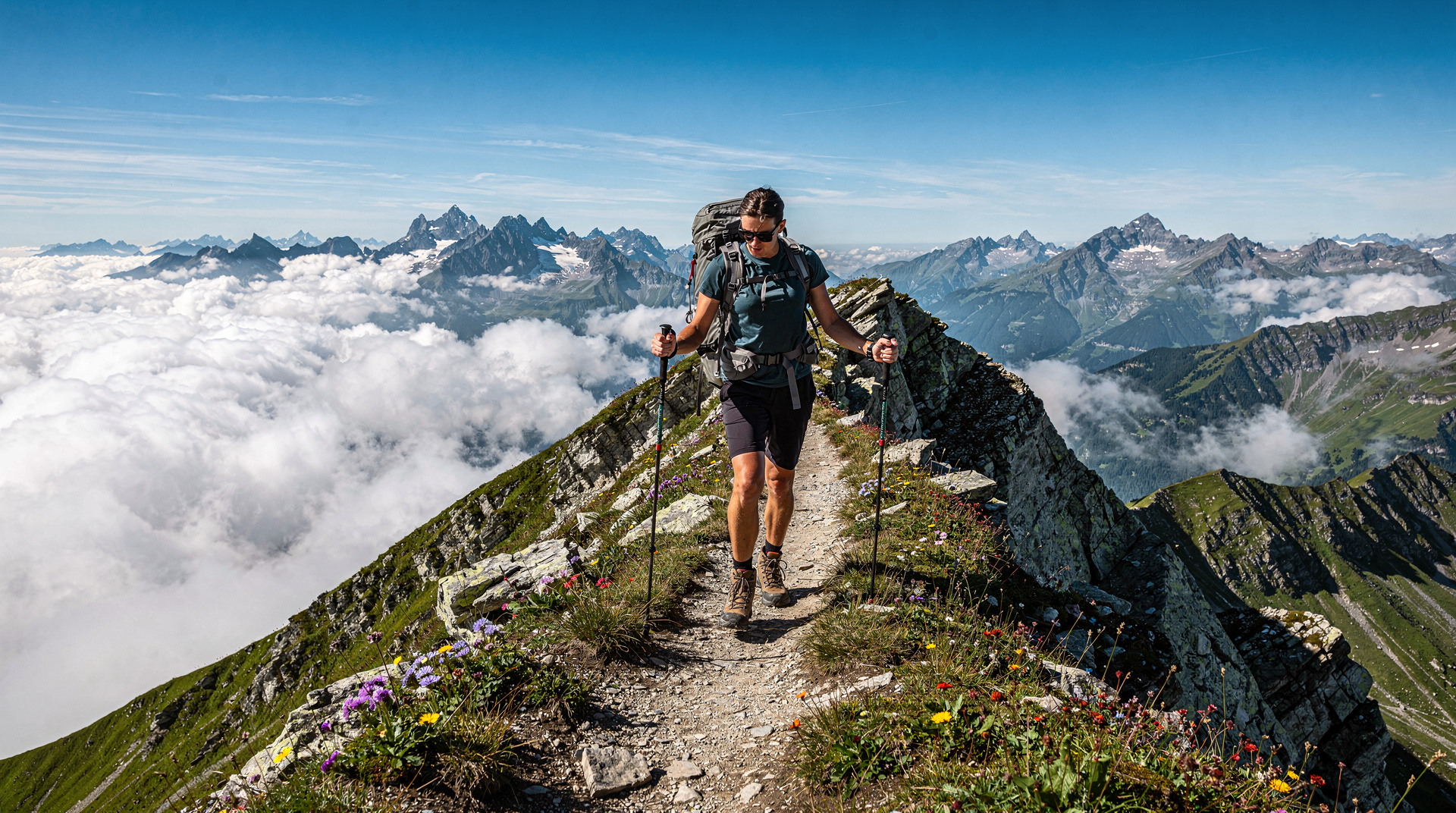
The Walker’s Haute Route is the benchmark Alpine long-distance walk — 200km from Chamonix in France to Zermatt in Switzerland, crossing 14 stages and 11 passes, with a maximum altitude of 3,371m at the Col de Sorebois. The route passes through some of the most spectacular high-alpine terrain in Europe: the Grand Combin massif, the Valais 4,000-metre peaks, the Col de Torrent, the Val d’Hérens, and the final dramatic approach to Zermatt.
Route overview:
The full walker’s route (as distinct from the ski mountaineering Haute Route that traverses glaciers) begins in Chamonix and crosses into Switzerland at the Grand Col Ferret, entering the Val Ferret. The Swiss section of the route covers the full width of the Valais, from Champex-Lac through Verbier, Arolla, Les Haudères, Grimentz, and Zinal before the final stages to Zermatt via St-Niklaus.
Key stages:
- Champex to Verbier (Stage 3 of Swiss section): A demanding day crossing the Mont Catogne and descending to Verbier. The views of the Grand Combin from the high point are extraordinary.
- Col de Louvie (Stage 5): The crossing of this 2,921m pass involves rough terrain and in early season possible snow. The descent to Lac du Midi is one of the route’s most dramatic sections.
- Col de Torrent to Grimentz (Stage 8): The highest pass on the Swiss section (3,301m) with a panorama encompassing dozens of 4,000-metre peaks.
- Zinal to Gruben to St-Niklaus (Stage 11): A long, demanding stage crossing the Meidpass with the Zinalrothorn, Obergabelhorn, and Weisshorn visible throughout.
- St-Niklaus to Zermatt (Final stage): The approach to Zermatt through the Mattertal, with the Matterhorn revealing itself progressively as the valley narrows.
Difficulty: Demanding. The route is suitable for experienced mountain walkers with good fitness. Daily ascents of 1,000-1,500m are typical. Some stages involve rough terrain, scree, and possible late-season snow on high passes. No technical climbing is required.
Duration: 12-16 days depending on pace and rest days.
Hut booking: Essential. The main accommodation on the Haute Route is in valley guesthouses, small alpine hotels, and some SAC huts. The route is popular, particularly in July and August — book accommodation at least three months in advance, and six months for the most popular sections (Champex, Verbier, Arolla).
Best single-stage sample: Grimentz to Zinal via the Col de Moiry is one of the finest single days on the entire Alpine walking network. The Lac de Moiry is accessible by bus from Grimentz, allowing non-trekkers to join from the valley. Zinal is reached by afternoon, with the Weisshorn dominating the view throughout.
Getting there: Geneva or Zurich to Chamonix by train and bus; Swiss Travel Pass covers Swiss sections. Return from Zermatt by train (Swiss Travel Pass valid).
Via Alpina: crossing Switzerland
The Via Alpina is a trans-European long-distance route that crosses eight Alpine countries from Trieste in Slovenia to Monaco. The Swiss section — Red Trail in Via Alpina nomenclature — is a 20-stage, 400km traverse of Switzerland from Vaduz in Liechtenstein to Montreux on Lake Geneva, crossing from east to west through the full range of Swiss Alpine terrain.
Route character:
Unlike the Haute Route’s consistent Valais focus, the Via Alpina Swiss section moves through contrasting landscape types: the Rhine valley, the Graubunden Alps, the central Swiss Alps, the Bernese Oberland, and finally the pre-Alps above Lake Geneva. Each region has a distinct character, and the route captures this diversity.
Key sections:
- Vaduz to Malbun (Stage 1-2): The Liechtenstein section is gentle and accessible, a good start for building into the route’s demands.
- Flims to Vals (Stage 4): Crossing the Valserberg (2,502m) from the Graubunden village of Flims to the spectacular thermal spa town of Vals.
- Sedrun to Amsteg via the Gotthard region (Stage 6-7): The route crosses the Fellilücke (2,476m) in the heart of Switzerland’s mountain watershed. The cultural significance of the Gotthard as the symbolic heart of Switzerland is palpable here.
- Meiringen to Grindelwald (Stage 12): The Grosse Scheidegg crossing (1,962m) from the Hasli valley into the Grindelwald basin with the Wetterhorn increasingly dominant.
- Kandersteg to Adelboden via the Bunderchrinde (Stage 16): A demanding high pass crossing between two of the Bernese Oberland’s most rewarding valley destinations.
- Château-d’Oex to Montreux via the pre-Alps (Stage 19-20): The final stages descend through Fribourg pre-Alps and the Lavaux vineyard landscape to Lake Geneva. The contrast between the high mountains of the interior and the warm lakeside finish is dramatically satisfying.
Difficulty: Moderate to demanding depending on stage. Several sections involve significant daily ascent. Some passes in early season (June) may have snow.
Duration: 20 stages. Most hikers complete the Swiss section in 16-22 days allowing for rest days and weather delays.
Hut and accommodation booking: The Via Alpina route is comprehensively served by valley accommodation (guesthouses, hotels) and some SAC huts on high sections. Booking 2-4 weeks in advance is typically adequate in June and September; July-August requires 4-6 weeks ahead on popular stages.
Via Alpina infrastructure: The Via Alpina website (via-alpina.org) provides stage-by-stage maps, accommodation listings, and GPX trail files. Each stage is marked on the ground with official Via Alpina trail markers.
Best single-stage sample: Stage 12 (Meiringen to Grindelwald via Grosse Scheidegg) is one of the most accessible and rewarding single stages, with bus service from Meiringen to Rosenlaui allowing a shorter day if needed. Covered by the Swiss Travel Pass.
Tour du Mont Blanc: Swiss section
The Tour du Mont Blanc (TMB) is the world’s most popular long-distance mountain walk — a 170km circuit of the Mont Blanc massif crossing France, Italy, and Switzerland. The Swiss section (3 of the 11 traditional stages) enters Switzerland at the Grand Col Ferret, crosses the Val Ferret, and reaches Champex-Lac before continuing into France via the Fenêtre d’Arpette or the Col de la Forclaz.
Swiss stages:
- Grand Col Ferret to La Fouly (Stage 7): The border crossing from Italy at 2,537m is one of the finest viewpoints on the full TMB — the Mont Blanc massif directly behind, the Swiss Val Ferret ahead. The descent to La Fouly takes approximately 3 hours.
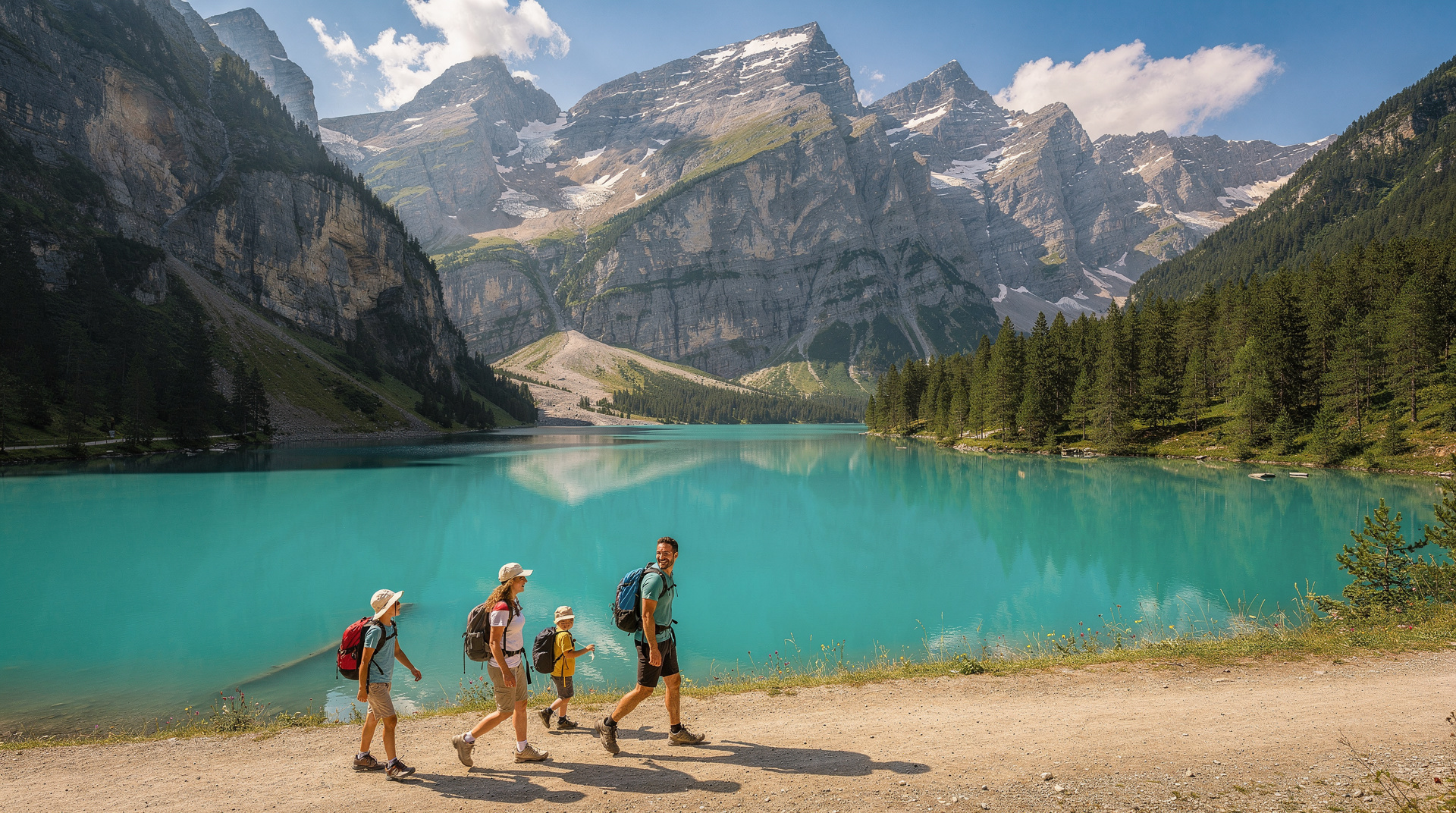
- La Fouly to Champex (Stage 8): A valley walk through the lower Val Ferret to the beautifully situated Champex-Lac, a small resort lake that provides a welcome mid-circuit pause.
- Champex to Trient via the Fenêtre d’Arpette (Stage 9, demanding variant): The Fenêtre d’Arpette variant (2,665m) is the highest point on the TMB circuit and involves some scrambling on the Swiss side. The alternative Bovine route via the Col de la Forclaz is easier and equally scenic.
Doing just the Swiss section: The Swiss section of the TMB is self-contained and logical — three days from the Italian border at Grand Col Ferret to Trient or Martigny. Reaching the start requires transport from Courmayeur in Italy (bus service in summer) or Chamonix.
TMB logistics: The TMB is extremely popular, with approximately 50,000 walkers per year in high season. Huts on the Swiss section — Gîte La Fouly, Refuge du Col de la Forclaz — book out months in advance for July and August. Book as early as possible.
Bernese Oberland: the Alpine Pass Route
The Alpine Pass Route (Alpenpässeweg) is a 15-stage, 340km traverse of the Bernese Oberland from Sargans to Montreux, crossing 16 passes. Fully within Switzerland, it is the most accessible of the major Swiss long-distance routes — all sections are reachable by public transport if weather intervenes, and accommodation throughout is in well-established valley and mountain facilities.
Best section: Stages 8-11 from Grindelwald through Grosse Scheidegg, Meiringen, Grimselpass, and Realp combine the finest Bernese Oberland scenery with the dramatic Grimsel reservoir landscape. These four stages can be done independently as a four-day circuit from Interlaken.
Planning essentials for multi-day trekking in Switzerland
Physical preparation: Multi-day Alpine trekking requires solid cardiovascular fitness and the ability to handle repeated daily ascents of 800-1,500m with a loaded pack. Training walks with a loaded pack in the months before the trip are essential.
Equipment: Walking boots with ankle support (essential, not optional), poles (strongly recommended), layers for all conditions including waterproofs and insulation, sun protection for high-altitude exposure, and a small first aid kit. For passes with possible snow, microspikes or lightweight crampons add security.
Navigation: All routes are well-marked on the ground, but carrying 1:25,000 scale maps (SwissTopo) as backup is strongly recommended. GPS track files are available for all major routes from the respective websites.
Hut etiquette: Most Swiss Alpine huts (SAC) operate on the assumption of dinner, overnight stay, and breakfast. Bring earplugs for dormitory sections. Huts typically require booking — walk-ins are increasingly rare in peak season.
Weather: Check MeteoSwiss forecasts daily. Bad weather on high passes (particularly the 3,000m-range crossings on the Haute Route and Via Alpina) can make sections dangerous. Build flexibility into your itinerary for weather days.
Emergency resources: The Swiss emergency number is 112. The Swiss Rega helicopter rescue service operates throughout the Alps; register at rega.ch before your trip.
The Via Alpina guide covers the full 20-stage Swiss route in depth. The best hikes guide covers single-day walking that can supplement or substitute for multi-day itineraries. The adventure itineraries guide offers multi-day programmes combining trekking with other Swiss outdoor activities.
Mountain hut culture on Swiss long-distance routes
The SAC (Swiss Alpine Club) hut network is integral to multi-day trekking in Switzerland. Understanding hut culture makes the experience significantly more enjoyable:
Booking: SAC huts require advance reservation, particularly in July and August. Booking opens in early spring for the following summer. The SAC website (sac-cas.ch) has a hut booking system for member and non-member reservations.
Hut meals: Dinner is typically served communally at a fixed time (usually 19:00-19:30). Menu is limited but substantial — soup, main course (often pasta, risotto, or a meat dish), and dessert. Breakfast is early (typically 06:00-07:00) to allow early alpine starts. Bring lunch from the valley or from the hut’s packed lunch service.
Dormitory accommodation: Most SAC huts offer Massenlager (dormitory accommodation) — bunks in shared rooms of 8-20 people. Bring a sleeping bag liner (mandatory in most huts; a sleeping bag is often not needed as huts provide blankets). Earplugs are essential.
Boots off: Remove hiking boots at the hut entrance and wear hut shoes (provided or available for hire). Huts are typically clean and well-run; the system depends on all users following the protocols.
Hut warden relationships: The hut warden (Hüttenwart) is a crucial resource for local conditions, route advice, and weather information. A brief conversation in the morning before setting out is worthwhile. Wardens know their terrain better than any map or app.
Acclimatisation for high-altitude trekking
The Haute Route and Via Alpina involve several days above 2,500m and passes at 3,000-3,300m. For most people arriving from sea level, some degree of acclimatisation is beneficial:
Typical acclimatisation programme: Spend 1-2 nights at 1,500-2,000m before attempting the highest passes. On the Haute Route, spending the first night in Chamonix (1,035m) and the second in Champex (1,466m) before the higher Swiss sections is a natural acclimatisation progression.
Symptoms of altitude sickness: Headache, nausea, fatigue, and disturbed sleep are the most common symptoms above 2,500m. These typically resolve within 24-48 hours of acclimatisation. Descending immediately is necessary if symptoms include loss of balance, confusion, or persistent vomiting.
Hydration: High altitude causes increased water loss through breathing. Drink at least 3 litres of water per day on high-altitude stages regardless of whether you feel thirsty.
Photography on multi-day routes
Multi-day trekking provides photographic opportunities that day hikes cannot: the quality of light at dawn and dusk from high mountain positions, the changing character of the same peaks across different days and light conditions, and the cumulative narrative of a long journey through mountain terrain.
The Haute Route in particular is one of the world’s most photographed long-distance walks. The classic images — the Grand Combin at sunrise from the Col de Louvie, the Weisshorn above Zinal, the Matterhorn approach from the Tête Blanche area — are each the result of being in the right place at the right time of day.
Camera weight is a genuine consideration on multi-day routes. A mirrorless system camera with a single versatile lens (24-105mm equivalent) is the best balance of image quality and pack weight. Smartphone cameras have improved to the point where they are adequate for most conditions except very low light and action at distance.
Support logistics: luggage transfer
Several services on the Haute Route and via Via Alpina’s lower sections offer luggage transfer — your main bag transported by vehicle from village to village while you walk with only a day pack. This dramatically reduces the physical difficulty of the trek and is worth considering for those whose fitness is adequate for the distances but who find pack weight limiting.
Local taxi services in the Valais offer informal luggage transfers on the Haute Route. Specialist Haute Route tour operators include luggage transfer as standard in their packages. The Via Alpina has a similar service through regional transport operators in some sections.
The Swiss Travel Pass does not cover special luggage transfer services, but it covers the return rail journey at the end of the trek — essential for getting home from Zermatt (Haute Route finish) or Montreux (Via Alpina finish) without needing a car or expensive transfers.
Guided versus independent multi-day trekking
The choice between guided and self-guided trekking on Switzerland’s long routes deserves consideration:
Guided trekking: Commercial tour operators (including Wilderness Travel, Sherpa Expeditions, and several Swiss-based companies) offer fully guided Haute Route packages. The guide handles logistics, leads the route, and manages accommodation. Group sizes typically 8-12 people. Advantages: social experience, no logistics management, expert local knowledge. Disadvantages: higher cost (typically CHF 4,000-7,000 per person for a 12-14 day Haute Route), fixed itinerary, group pace.
Self-guided with operator support: The same operators offer self-guided versions where the company books accommodation, provides detailed route notes and maps, and arranges luggage transfers, but the hiker walks independently. Typically 25-40 percent less expensive than guided. This is the most popular format for experienced hikers on the Haute Route.
Fully independent: Book everything yourself using the SAC hut booking system, ValaisWalking.com, and the Via Alpina website. Maximum flexibility, lowest cost, highest logistics burden. Appropriate for experienced mountain hikers with strong navigation skills and the confidence to manage weather decisions independently.
The physical and mental challenge
Multi-day Alpine trekking is genuinely demanding in ways that shorter hikes do not reveal. Several specific challenges distinguish the long-distance Alpine experience:
Cumulative fatigue: Days 5-8 of a multi-week trek are typically the hardest. The initial enthusiasm carries the first four days; the end is not yet in sight; and accumulated muscle micro-damage from daily 6-8 hour efforts with loaded packs creates a tiredness different in character from single-day exhaustion. This period is when the resolve to continue is genuinely tested.
Mental adaptation: After 5-7 days of continuous trekking, most hikers report a mental shift — the concern about pace, weather, and arrival times recedes, and a more immediate engagement with the landscape develops. This state, sometimes described as “trail mind,” is one of the primary rewards of multi-day trekking and cannot be accessed on day hikes.
Foot care: Blisters, hotspots, and nail bruising are the most common physical problems on long Alpine routes. Prevention through well-fitted boots (broken in before the trek), appropriate socks (merino wool or technical synthetic, no cotton), and daily inspection and tape application is significantly more effective than management after the problem develops.
Nutrition: The caloric demand of 8 hours of mountain walking with a 10kg pack at altitude is 3,500-5,000 calories per day — far above normal. Hut meals may not fully compensate; carrying high-calorie snacks (nuts, dried fruit, chocolate) and eating proactively throughout the day rather than waiting for hunger maintains performance.
Switzerland as a trekking destination: the broader picture
The three major routes described in this guide represent only a fraction of Switzerland’s long-distance walking network. The country has approximately 65,000km of marked trails, of which perhaps 10,000km are suitable for multi-day trekking in the sense of routes with regular accommodation and food provision.
Regional routes — the Tour du Jura, the Alpenpässeweg, various cantonal long-distance paths — offer multi-day experiences for those who have completed the major routes or who prefer lower altitudes and less exposure. The Via Alpina guide covers the most ambitious cross-Switzerland option. The best hikes guide places single-day walks within the longer-route context.
For those considering Switzerland as a trekking destination for the first time, the Bernese Oberland’s Alpine Pass Route (Stages 8-11, Grindelwald to Kandersteg via Grosse Scheidegg and Meiringen) provides a superb 4-5 day introduction to multi-day Swiss trekking at lower altitude and with excellent infrastructure throughout — a perfect preparation for the more demanding Haute Route or Via Alpina in subsequent years.