15 best hikes in Switzerland: routes for all levels
What is the best hike in Switzerland?
The Five Lakes Walk in Zermatt is Switzerland's most celebrated day hike, combining stunning Matterhorn views with five alpine lakes. The Schilthorn Panorama Trail and the walk from Männlichen to Kleine Scheidegg are close rivals for scenery.
Switzerland’s hiking landscape: why it is exceptional
Switzerland has approximately 65,000km of signposted hiking trails — a number that puts it among the most extensively networked walking nations on earth, particularly remarkable for a country covering only 41,000 square kilometres. More than that, the trails are consistently maintained, accurately signposted with yellow markers giving time estimates to the next destination, and connected to a public transport infrastructure that makes point-to-point walks logistically straightforward without a car.
The terrain ranges from gentle lakeside promenades at 300m altitude to high-Alpine routes at over 3,000m crossing glaciers and ridges. The best hikes concentrate a remarkable density of scenery — glaciers, rock faces, mountain lakes, wildflower meadows, waterfalls — into accessible day trips from valley bases.
This guide presents 15 of the best, organised loosely from less to more demanding. Each listing includes distance, elevation gain, recommended time, starting point, and what makes it worth the effort.
Five Lakes Walk — Zermatt guided excursion
Experience Switzerland's most celebrated day hike with a guided excursion from Zermatt, passing five alpine lakes with reflections of the Matterhorn at every turn.
- Free cancellation
1. Five Lakes Walk, Zermatt
Distance: 15km | Elevation gain: 320m | Time: 4-5 hours | Difficulty: Easy-moderate
The Five Lakes Walk (Fünf-Seen-Wanderung) is the single most celebrated day hike in Switzerland. The route traverses the mountain above Zermatt between the Sunnegga and Rotenboden lift stations, passing five alpine lakes — Stellisee, Grindjisee, Grünsee, Moosjisee, and Leisee — each offering a different reflection of the Matterhorn in its surface.
Start at Sunnegga (reached by underground funicular from Zermatt, approximately 10 minutes), and walk the circuit ending at Rotenboden, where the classic Riffelsee reflection of the Matterhorn is the most photographed image in Swiss hiking photography. Return to Zermatt by the Gornergrat Railway from Rotenboden.
The altitude range (2,200-2,800m) keeps the route cool in summer and the views constant. Arrive early on clear summer days; the morning light on the Matterhorn is best before 10:00 and the trails become busy by late morning. Book the Five Lakes Walk excursion from Zermatt to combine the hike with a guided Matterhorn glacier experience.
2. Männlichen to Kleine Scheidegg
Distance: 6km | Elevation gain: 70m (mostly descent) | Time: 2 hours | Difficulty: Easy
This is the most famous “easy” hike in Switzerland — a nearly flat high-ridge walk from the Männlichen summit (2,343m) to Kleine Scheidegg (2,061m) with the Eiger north face directly in front of you for the entire route. The Eiger, Mönch, and Jungfrau form a continuous wall of rock and ice across the valley, visible from start to finish.
Reach Männlichen by cable car from Wengen or gondola from Grindelwald. Walk the gentle ridge trail to Kleine Scheidegg, then return by Wengernalpbahn train to Wengen or Grindelwald. The Swiss Travel Pass covers the Wengernalpbahn railway.
The walk is suitable for all ages and fitness levels. The only caveat: do it on a clear day; fog or cloud reduces the experience from spectacular to pleasant. Pre-book the Grindelwald gondola and Männlichen access to avoid queues on busy summer mornings.
3. Bachalpsee from Grindelwald First
Distance: 6km return | Elevation gain: 200m | Time: 2 hours | Difficulty: Easy
The trail from Grindelwald First (2,168m) to the Bachalpsee lakes is one of Switzerland’s most rewarding short hikes. The two interconnected lakes sit in a natural bowl below the Faulhorn, their surface reflecting the Wetterhorn and Schreckhorn when calm. The approach from First is on a well-maintained path with consistent views.
Book your Grindelwald First cable car ticket — the cable car is the starting point for this and several other excellent hikes.
4. Oeschinensee, Kandersteg
Distance: 7km return | Elevation gain: 300m | Time: 2.5 hours | Difficulty: Easy
The Oeschinensee (Oeschinen Lake) above Kandersteg is one of Switzerland’s most beautiful alpine lakes — a deep, turquoise basin ringed by the vertical limestone walls of the Blümlisalp. The approach from the cable car station (or on foot from Kandersteg) reaches the lake through forest and then open meadow.
Rowing boats can be hired on the lake in summer. Camping above the lake provides some of Switzerland’s finest wild camping views. The lake also serves as the starting point for the demanding ascent to the Fründenbach shelter and beyond.
5. Schilthorn Panorama Trail, Mürren
Distance: 16km (Schilthorn to Grütschalp) | Elevation gain: 300m | Time: 5-6 hours | Difficulty: Moderate
The trail descending from the Schilthorn (2,970m) toward Mürren and continuing along the cliff-edge traverse to Grütschalp is one of the great mountain walks in Europe. The southern outlook toward Eiger, Mönch, Jungfrau, and the Lauterbrunnen Valley (1,000 metres below) remains constant for most of the walk. The first section from Schilthorn to Mürren (approximately 3km) is steep and involves rough terrain; the subsequent ridge walk to Grütschalp is more moderate.
Start at Schilthorn (cable car from Stechelberg via Mürren) and descend by cable car and train from Grütschalp back to the valley.
6. Rigi-Kulm circuit
Distance: 10km | Elevation gain: 400m | Time: 3.5 hours | Difficulty: Easy-moderate
The Rigi summit plateau above Lake Lucerne offers hiking with panoramic lake views that rival the Alpine scenery further south. The circuit from Rigi-Kulm (1,797m) around the plateau and back via Rigi-Staffel and Rigi-Kaltbad covers all the best viewpoints. The Kaltbad mineral spring and spa at the end of the walk provides an excellent post-hike recovery option.
The Rigi rack railway from Vitznau or Arth-Goldau is covered by the Swiss Travel Pass. Book the classic Rigi round-trip from Lucerne including the rack railway and lake cruise.
7. Lavaux Vineyard Terrace Walk
Distance: 15km (Lausanne to Vevey) | Elevation gain: 500m | Time: 5 hours | Difficulty: Easy-moderate
The Lavaux vineyards east of Lausanne are a UNESCO World Heritage Site — terraced vines descending to Lake Geneva, planted on south-facing slopes since the 12th century when Cistercian monks first cultivated them. The trail through the vineyards connects the villages of Lutry, Cully, Rivaz, St-Saphorin, and Chexbres, always with the lake and the Savoy Alps visible below.
Walk in June during flowering season or in September-October during the harvest. Several village restaurants serve local wines and regional food along the route. Book the Lavaux vineyard walking experience from Lausanne with a local guide who knows the best tasting stops.
8. Gornergrat circuit, Zermatt
Distance: 12km | Elevation gain: 600m | Time: 4-5 hours | Difficulty: Moderate
The circular route from the Gornergrat station (3,089m) around the ridge above Zermatt with views of the Monte Rosa massif, the Matterhorn, and the Gorner Glacier below is one of the most dramatic high-alpine walks accessible without mountaineering experience. Start by taking the Gornergrat Railway from Zermatt, hike the ridge circuit, and return on foot to Zermatt or by a lower train station.
The altitude means thin air and UV exposure — take the acclimatisation seriously if arriving from sea level. Book the Zermatt village and Gornergrat private guided tour for expert narration on the geology and local history.
9. First to Schynige Platte (Faulhorn route)
Distance: 16km | Elevation gain: 800m | Time: 6-7 hours | Difficulty: Demanding
The classic high-level ridge traverse from Grindelwald First (2,168m) over the Faulhorn (2,681m) to Schynige Platte (1,967m) is one of the finest long day walks in the Bernese Oberland. The Faulhorn summit provides 360-degree views combining the Eiger massif to the south with the Brienzersee and Thunersee lakes to the north.
The trail is well-marked but the Faulhorn section is exposed and requires good footwear and fitness. Finish by taking the rack railway from Schynige Platte down to Wilderswil, covered by the Swiss Travel Pass.
10. Blausee nature reserve walk
Distance: 4km loop | Elevation gain: 50m | Time: 1.5 hours | Difficulty: Easy
The Blausee is a small, extraordinarily clear lake in the Kandertal valley south of Kandersteg, fed by subterranean springs that filter through the rock and emerge at the lake floor at 6 degrees year-round, giving the water its vivid turquoise-blue colour. The trail circuiting the lake and the surrounding nature reserve is short and accessible to all fitness levels.
Trout are visible through the crystal-clear water from the lake shore. The surrounding forest provides pleasant walking even in hot summer weather. The adjacent Blausee Hotel has a good restaurant.
11. Graubunden: Weg der Schweiz (Swiss Path)
Distance: 35km total; various day sections | Elevation gain: Varies | Time: 2 days in sections | Difficulty: Moderate
The Swiss Path circles Lake Uri (the southern arm of Lake Lucerne), running 35km from Brunnen to Bauen via the Rütli meadow — the site of the legendary founding oath of the Swiss Confederation. The path was created in 1991 for the 700th anniversary of the confederation, with each canton responsible for a section proportional to its population.
The trail is divided into accessible sections, each reachable by boat from Brunnen or Flüelen. The combination of historical significance, lakeside scenery, and the ferry infrastructure makes this one of the most rewarding multi-section walks in central Switzerland.
12. Aletsch Glacier trail
Distance: 12km | Elevation gain: 300m | Time: 4 hours | Difficulty: Moderate
The trail along the rim above the Aletsch Glacier — the largest glacier in the Alps at 23km length — is a UNESCO World Heritage walk that requires no mountaineering but delivers an experience of glacial scale that few other walks can match. Access from Bettmerhorn (cable car from Bettmeralp) or Eggishorn above Fiesch.
The trail runs along the moraine ridge above the glacier, with the ice field visible throughout. Information boards explain the glacier’s formation, history, and current rate of retreat. Book an Aletsch Glacier day trip from Zurich with transfers to the cable car access point included.
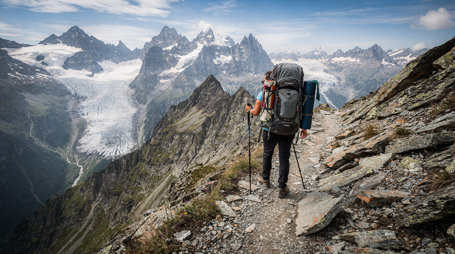
13. Haute Route section: Champex to Verbier
Distance: 15km | Elevation gain: 1,400m | Time: 7-8 hours | Difficulty: Demanding
A single stage of the famous Haute Route (covered in full in the multi-day treks guide) from Champex-Lac to Verbier crosses high-alpine terrain above the treeline with views of the Grand Combin massif. This is demanding hiking requiring full mountain equipment, weather awareness, and solid fitness, but accessible to experienced day hikers who don’t want to commit to the full multi-day route.
14. Appenzell: Säntis ascent
Distance: 10km return | Elevation gain: 1,200m | Time: 5-6 hours | Difficulty: Demanding
The ascent to the Säntis summit (2,501m) from Schwägalp by foot (rather than cable car) is one of eastern Switzerland’s classic mountain walks. The trail is steep and requires sure footedness, but the 360-degree panorama from the summit — Lake Constance to the north, the Glarus Alps to the south, and on exceptional days the Alps of several countries — repays the effort completely.
15. Piz Languard, Pontresina (Engadin)
Distance: 8km return | Elevation gain: 900m | Time: 4-5 hours | Difficulty: Demanding
The ascent of Piz Languard (3,262m) from Pontresina via the Chamanna Segantini is one of the most accessible 3,000-metre summits in the Alps, with a marked trail and no technical climbing required. The summit view encompasses the entire Bernina massif, the Engadin valley, and (on clear days) Monte Rosa and the Matterhorn to the west. The Segantini hut midway up, named for the Swiss-Italian painter who worked in the Engadin, serves refreshments.
Planning tips for Swiss hiking
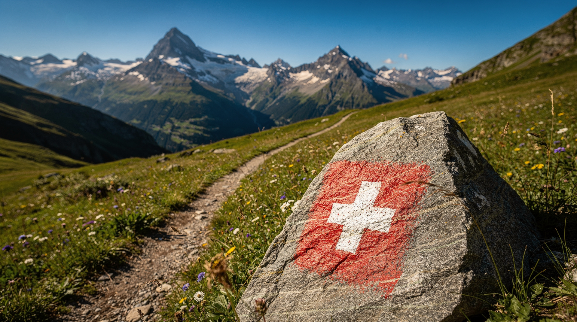
Trail marking: Swiss trails use a consistent colour-coded marking system. Yellow signs indicate standard hiking routes (all abilities). White-red-white markings indicate mountain routes requiring sure-footedness. White-blue-white indicates alpine routes requiring mountaineering experience.
Transport: The Swiss Travel Pass covers most transport to trailheads, including many mountain railways and cable cars at discounted rates.
Weather: Swiss mountain weather changes rapidly. Carry rain gear and an extra layer regardless of morning conditions. Afternoon thunderstorms in summer are common; plan to be below exposed ridges by 14:00.
Season: The prime hiking season runs from late June to mid-October. High-altitude routes (above 2,500m) may have snow patches until late July. The best time to visit Switzerland covers seasonal conditions in detail.
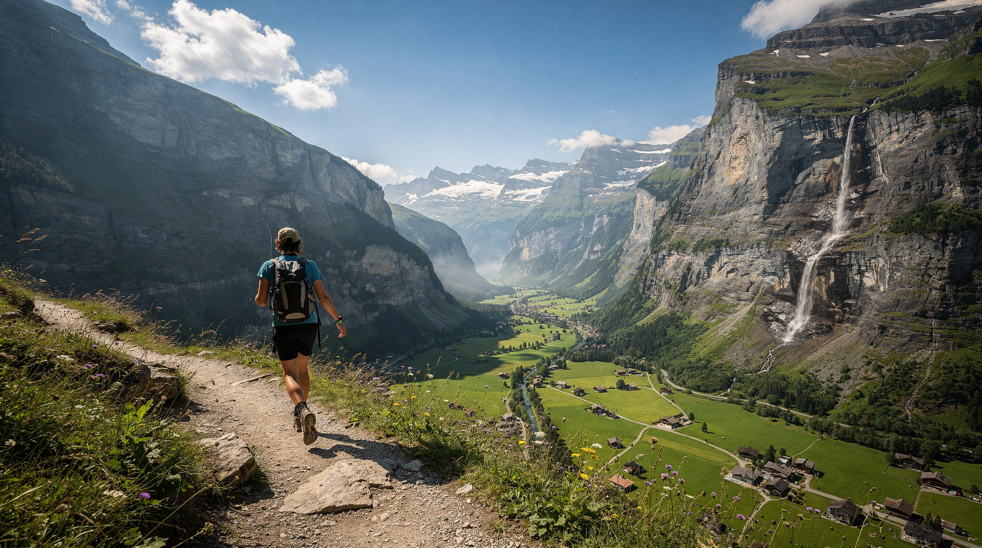
For easy hikes with families, the Lauterbrunnen area offers some of the most accessible dramatic scenery in Switzerland. The Via Alpina guide covers the full cross-Switzerland long-distance route for dedicated trekkers.
Mountain huts on Swiss trails
The Swiss Alpine Club (SAC) maintains a network of over 150 mountain huts across the Alps, many of which are accessible as day destinations from the valley trails listed above. Stopping at an SAC hut for lunch adds a social and architectural dimension to a hike — these are functional, unornamented shelters built to withstand Alpine storms, with communal dining tables and simple menus of soup, pasta, and tea.
The Faulhorn Hotel above Grindelwald (hike 9 in this guide) is the oldest continuously operating mountain guesthouse in Switzerland, founded in 1832. It can accommodate overnight guests for multi-day itineraries and serves meals to day hikers. The Schynige Platte Berghotel, the Weissmies Hut in the Saas valley, and the Rotstock Hut above Kandersteg are among the most rewarding lunch stops within day hike reach.
SAC hut overnight stays require SAC membership (approximately CHF 80/year for international members) for priority booking and member pricing. Day visitors and non-members can typically use hut restaurants without booking.
Hiking apps and navigation tools
Switzerland’s hiking trail network is comprehensively mapped in several digital formats:
SwissTopo app: The official Swiss national mapping application provides 1:25,000 scale maps (the most detailed available) with GPS tracking and offline capability. The app is free; map layers require subscription or individual purchase. Essential for any hike above the valley floor.
Outdooractive: A widely used hiking and outdoor navigation app with Switzerland well-covered. Includes community-generated GPX tracks for most major routes and several alternatives.
SchweizMobil (Wanderland): The official Swiss hiking federation app, listing all officially marked trails with conditions reporting and downloadable offline maps. Particularly useful for finding local trails in unfamiliar areas.
SLF Avalanche Bulletin: Not a navigation tool, but the SLF daily avalanche bulletin at slf.ch is essential context for anyone hiking above the treeline in spring (when wet avalanche risk is high even on summer routes) or after heavy snowfall.
Hiking and Swiss culture: the Älplerchilbi
Visitors who hike the Swiss mountain trails in late summer and autumn may encounter one of the most vivid Swiss folk traditions: the Älplerchilbi, or Alpine farmer’s festival, held in October as the cattle descend from the high pastures. Communities in the Bernese Oberland, Glarus, and Appenzell mark the end of the Alpine summer with brass band concerts, traditional wrestling (Schwingen), flag throwing, yodelling, and enormous communal meals.
Several of the most accessible Älplerchilbi events occur in villages directly on or near major hiking routes. The Haslital and Diemtigtal in the Bernese Oberland, and the Appenzell village of Appenzell itself, are among the most rewarding to visit during this season. The combination of completing a hike and arriving in a village mid-celebration is one of those unplanned Swiss travel experiences that stays in memory.
Planning hiking holidays around Swiss festivals
The Swiss hiking season from June to October overlaps with several major cultural events covered in the festivals guide. The Swiss National Day on August 1 is celebrated in every mountain village with fireworks and signal fires. Planning a high-altitude hike for the evening of August 1 — with fires lit on visible peaks across the landscape — is one of the most distinctly Swiss experiences possible.
The Alpabzug (cattle descent) from August through October creates encounters with working Alpine agriculture directly on major hiking routes. The lavender harvest in Valais in July perfumes valley approaches to the high routes in that region. Swiss hiking is not only about the mountain scenery — it is also a window into a rural culture that remains remarkably continuous with its historical form.