Via Alpina Switzerland: the complete crossing guide
How long does the Via Alpina take to walk in Switzerland?
The Swiss section of the Via Alpina (Red Trail) covers 20 stages and approximately 400km from Vaduz to Montreux. Most walkers complete it in 18-24 days including rest days, typically walking June to September.
Via Alpina: crossing Switzerland on foot
The Via Alpina is a trans-European long-distance route connecting eight Alpine countries from Trieste in Slovenia to Monaco on the Mediterranean coast. The Swiss Red Trail — one of five colour-coded routes in the system — traverses Switzerland from east to west in 20 stages, entering from Liechtenstein at Vaduz and ending at Montreux on Lake Geneva.
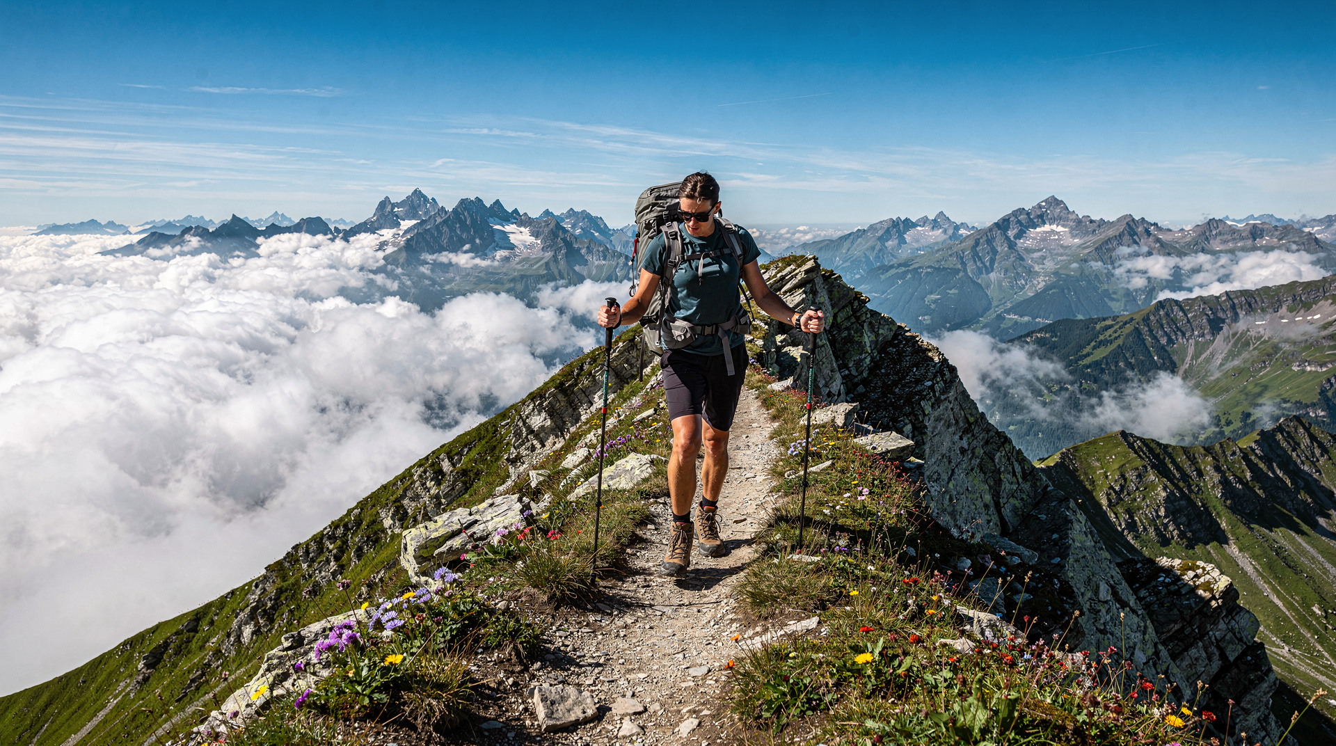
The route is 400km in length and covers an extraordinary diversity of Swiss Alpine terrain: the Rhine valley, the high peaks of Graubunden, the Gotthard massif at Switzerland’s geographic heart, the Bernese Oberland, and the pre-Alpine foothills above Lac Léman. No other long-distance route crosses such a complete cross-section of Swiss mountain culture.
Walking the Via Alpina requires 18-24 days of continuous effort, solid mountain fitness, and good logistical planning — particularly for hut and accommodation booking. But the rewards are commensurate: 20 days in the Swiss Alps at this level of intensity is a genuinely life-changing experience for those who complete it.
The 20 stages: overview
The stages below are the official Via Alpina Red Trail stages. The times given are typical for a fit walker; allow 20-30 percent more if carrying a heavy pack or in uncertain conditions.
Stage 1 — Vaduz to Malbun (Liechtenstein): 9km, 850m ascent. A short introductory stage ascending through Liechtenstein’s capital and into the mountains. Malbun is a small ski resort with simple guesthouses.
Stage 2 — Malbun to Sargans: 19km, 500m ascent. Descent from Liechtenstein into the Rhine valley at Sargans, the first Swiss town on the route. The Wartau castle ruin provides a scenic high point.
Stage 3 — Sargans to Elm: 24km, 1,450m ascent. The first serious Alpine stage, crossing the Gulmen (2,099m) into the Glarus Alps. Elm is a traditional Glarus village with a spectacular geological feature — the Martinsloch, a natural window in the rock through which the sun shines on specific dates.
Stage 4 — Elm to Linthal: 22km, 900m ascent. Through the Glarus Alps with views of the Tödi massif (3,614m). Linthal is at the head of the Linth valley.
Stage 5 — Linthal to Muotatal: 18km, 1,400m ascent. The Kistenpass (2,887m) is one of the route’s most demanding crossings, a high and sometimes snow-covered pass into the Muotatal — a traditionally conservative valley with one of Switzerland’s most intact folk cultures.
Stage 6 — Muotatal to Sisikon: 22km, 1,200m ascent. Descent via the Pragel Pass to Lake Uri and the historic Rütli meadow area. The Swiss national myth is particularly present in this section.
Stage 7 — Sisikon to Altdorf: 16km, 400m ascent. A lake and river stage through the Uri landscape of Tell and Swiss foundation mythology. Altdorf is the cantonal capital of Uri.
Stage 8 — Altdorf to Hospental: 25km, 1,600m ascent. The long stage into the Gotthard massif, approaching the Gotthard Pass via the Reuss valley. The Gotthard region is the geographic and symbolic heart of Switzerland.
Stage 9 — Hospental to Oberwald: 22km, 800m ascent. Crossing the Furkapass (2,429m) — one of the great Swiss passes — into the Goms valley of the Valais. The Rhône glacier at the pass head is retreating rapidly and dramatically visible.
Stage 10 — Oberwald to Binn: 18km, 1,100m ascent. Ascending from the Goms valley over the Albrunpass (2,409m) into the side valley of Binn, famous for its rare minerals and crystal formations.
Stage 11 — Binn to Saas Almagell: 24km, 1,500m ascent. A demanding high stage over the Antrona Pass (2,838m) — technically in Italy for a short section — descending to the Saas valley with the 4,000-metre peaks of the Mischabel range visible.
Stage 12 — Saas Almagell to Gruben: 19km, 1,300m ascent. Crossing the Augstbordpass (2,893m) between the Saas valley and the Turtmanntal. This high and sometimes demanding pass requires good conditions.
Stage 13 — Gruben to St-Niklaus: 18km, 900m ascent. Descent through the Turtmanntal and via the Augstbord ridge to the Mattertal. The Matterhorn becomes visible as the Mattertal is approached.
Stage 14 — St-Niklaus to Gruben (via Zermatt alternate): Note: The official route continues toward the Lötschenpass section; an unofficial but popular variant adds a detour to Zermatt for the Matterhorn views.
Stage 15 — St-Niklaus to Leukerbad: 22km, 1,600m ascent. Crossing the Gemmipass (2,322m) — one of the most historically important passes in the Alps, used since Roman times — to reach Leukerbad, famous for its thermal baths.
Stage 16 — Leukerbad to Kandersteg: 17km, 1,200m ascent. Crossing the Gemmi via the cable car descent into the Bernese Oberland at Kandersteg. The Gemmi Pass viewpoint is one of the finest on the route.
Stage 17 — Kandersteg to Adelboden: 15km, 1,300m ascent. The Bunderchrinde crossing (2,385m) between two of the Bernese Oberland’s most attractive valley destinations.
Stage 18 — Adelboden to Lenk: 16km, 900m ascent. A gentle Bernese Oberland stage through high meadows and farm country.
Stage 19 — Lenk to Château-d’Oex: 25km, 1,200m ascent. Crossing the Col du Jaman-Jaun Pass direction into the Fribourg pre-Alps. The cultural transition from German-speaking to French-speaking Switzerland is crossed on this stage.
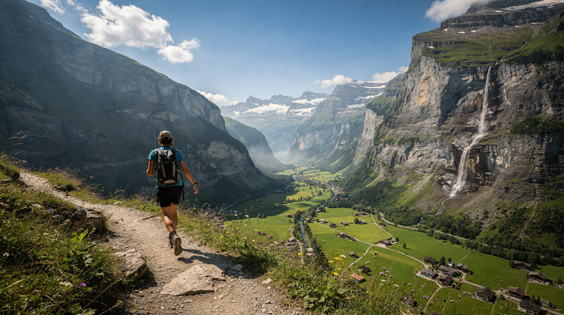
Stage 20 — Château-d’Oex to Montreux: 23km, 900m ascent. The final stage descends through the Fribourg and Vaud pre-Alps to Montreux and Lake Geneva. The view from the final ridge above the lake — the Savoy Alps across the water, the vineyards of Lavaux below — is an emotional and appropriate conclusion.
Hut and accommodation booking
The Via Alpina passes through a mix of high-Alpine SAC huts, simple valley guesthouses, and small hotels. Booking strategy depends on the section:
Stages 1-8 (eastern Alps): Accommodation is mainly valley-based in guesthouses. Advance booking of 2-4 weeks is typically adequate in June and September; 4-6 weeks for July-August.
Stages 9-14 (Valais high section): Includes SAC huts that must be booked well in advance — the Weissmies hut, the Turtmannhütte, and others on the high Valais section fill in July-August. Book SAC huts via the SAC website (sac-cas.ch) or directly by telephone 6-8 weeks in advance for peak season.
Stages 15-20 (Bernese Oberland and pre-Alps): Valley accommodation throughout. Leukerbad and Kandersteg have good hotel selections. Book 3-4 weeks ahead for summer.
Best sections for partial walking
If 20 days is not feasible, the following sections offer the best concentrated experience of the Via Alpina:
Stages 9-11 (Hospental to Binn): The Gotthard-Goms-Binn section crosses the Swiss geographic heart and includes the Furkapass and the extraordinary Rhône glacier. This is the most historically and geographically significant section.
Stages 15-17 (Leukerbad to Kandersteg): The Gemmi crossing is one of the great Swiss passes, and the section from Leukerbad to Kandersteg via the Gemmi and Kandersteg thermal area is a superb 3-day walk.
Stages 12-13 (Saas valley to Mattertal): The combination of high passes, Valais scenery, and the approach to Zermatt makes this section the most visually dramatic.
Practical logistics
Start and finish transport: Vaduz (Liechtenstein) is reached by PostBus from Buchs SG (15 minutes by train from Zurich). Montreux is a major SBB station connected to Geneva and Lausanne. The Swiss Travel Pass covers all SBB rail and many PostBus connections used to reach and from the route.
On-route transport: The Via Alpina Red Trail is designed to be walked completely, but several sections parallel PostBus routes that allow bail-out options in bad weather. The Goms valley (Stages 9-10) has bus service throughout. Kandersteg and Leukerbad have good rail and bus connections.
Maps: SwissTopo 1:25,000 maps cover the entire route. The Via Alpina website provides free GPX files for each stage. The official Via Alpina app provides navigation and stage information offline.
Pack weight: Target 8-10kg maximum (including water). Every extra kilogram is felt across 20 stages. Clothing for all conditions (rain, cold, heat), a compact sleeping bag liner for hut accommodation, and a basic medical kit.
Best time: Mid-June to late September. High passes are often snow-covered until mid-June; September conditions are excellent with lower crowds and cooler temperatures ideal for sustained daily walking.
Via Alpina compared to other Swiss treks
The Via Alpina is Switzerland’s most comprehensive long-distance route — crossing more cultural regions and terrain types than the Haute Route (which focuses on the Valais) or the Alpine Pass Route (Bernese Oberland focused). But the Haute Route is more consistently at higher altitude, more dramatic on individual days, and better known internationally.
For walkers choosing between them: the Via Alpina is the better choice for those who want a genuine cross-Switzerland experience; the Haute Route for those who want the most intense single-region mountain experience. Both are covered in the multi-day treks guide.
The Via Alpina website is the definitive planning resource, with stage-by-stage maps, accommodation databases, and condition reports. Swiss Tourism also provides Via Alpina route information and links to regional tourist offices along the route.
For physically demanding adventure experiences that combine trekking with other activities, the best hikes guide covers single-day alternatives within range of the Via Alpina stages, and the multi-day treks guide provides the broader context for planning extended Alpine walking in Switzerland.
Language regions on the Via Alpina
One of the distinctive features of the Via Alpina Red Trail is that it crosses all four of Switzerland’s official language regions. This cultural dimension adds interest that goes beyond the physical landscape:
German-speaking Switzerland (Stages 1-16): The majority of the route crosses German-speaking territory. Trail signs, hut wardens, and accommodation are primarily German-language, with English widely understood in tourist areas. The cultural character is practical, reserved, and deeply invested in outdoor tradition.
Italian-speaking Switzerland (Stage 11 passes through the Valais border area): The Antrona Pass route briefly enters Italian cultural territory in the Valais. The transition to Italian food culture (risotto, ossobuco, espresso rather than filter coffee) is felt even before the language officially changes.
French-speaking Switzerland (Stages 19-20): The final stages cross into Vaud and the Fribourg pre-Alps, where French is the daily language. The pace of life shifts subtly — meals are longer, the café culture is more prominent, and the approach to outdoor recreation is somewhat less rigorous than the German Swiss model.
Romansh-speaking areas: The Via Alpina does not directly traverse Romansh territory (concentrated in Graubunden’s inner valleys), but several stages are close to Romansh communities. Stage 3-4 through the Glarus Alps passes within range of the Romansh borderlands.
This linguistic journey within a single country of 260km is one of the Via Alpina’s unique qualities among long-distance Alpine routes.
Training and preparation for the Via Alpina
The 20-stage Via Alpina is a demanding commitment. The following preparation approach is used by experienced mountain walkers:
Six months before: Begin regular aerobic training. Running (three times per week, building to 10km per session), cycling, or swimming. Focus on cardiovascular capacity.
Three months before: Add loaded pack walking (8-10kg) on varied terrain. Build distance from 15km to 25km per loaded day. Include at least two multi-day test trips (two consecutive days with overnight accommodation).
One month before: Taper heavy training, maintain moderate activity. Walk in the boots you will use on the route — no new footwear on a 20-stage alpine trek.
Equipment check: Replace worn boot soles. Check that poles are at the correct height and mechanism works. Ensure waterproof jacket seams are sealed. Pack first aid kit and replace any expired medications.
Cultural encounters along the route
The Via Alpina passes through some of Switzerland’s most culturally specific communities. Several deserve particular note:
Muotatal (Stage 5-6): One of Switzerland’s most conservative and tradition-preserving valleys. The valley community has maintained its own distinct yodelling style, folk costumes, and local customs largely unchanged by external influence. The Muotathaler Wetterschmöcker (weather predictors) are renowned throughout Switzerland for their folk-meteorological forecasting — a tradition that predates modern meteorology by centuries.
Binn (Stage 10): The Val di Binn is one of Switzerland’s most remote inhabited valleys and famous among mineralogists for its exceptional crystal formations. The Mineralien Museum in Binn village displays the extraordinary geological heritage of the valley. The isolation of the community — until recently accessible only by a narrow footpath, now by a small mountain road — has preserved an authenticity rare in Swiss Alpine territory.
Leukerbad (Stage 15): The thermal springs at Leukerbad have been used since Roman times. The thermal bath culture here is genuine rather than touristic — locals use the baths regularly, and the 36-degree mineral water is genuinely medicinal in its mineral content. A Via Alpina stage ending at Leukerbad is one of the route’s most satisfying combinations of physical effort and recovery luxury.
After the Via Alpina: returning from Montreux
The conclusion of the Via Alpina Red Trail at Montreux is emotionally powerful — the lake visible below, the mountains receding behind you, the journey complete. Montreux itself provides an excellent post-trek celebration point: the lakefront promenade, the Chateau de Chillon a 20-minute walk or bus ride along the lake, and the restaurants of the town centre reward the achievement with genuine quality.
Return travel from Montreux is direct and comfortable. The train to Geneva takes 40 minutes; to Zurich approximately 2.5 hours with a change at Lausanne. Both are major international airports. The Swiss Travel Pass covers the return journey and remains valid for any remaining days of mountain exploration before departure.
Via Alpina: sustainability and environmental principles
The Via Alpina organisation is formally committed to sustainable tourism principles. The route is designed to use existing trail infrastructure rather than create new paths, to route through local communities rather than around them (ensuring economic benefit to valley villages), and to connect with public transport at sufficient intervals to allow car-free travel.
Walking the Via Alpina without a car is entirely practical — the Swiss public transport network (covered by the Swiss Travel Pass) reaches all the valley access points. For those travelling internationally to walk the route, taking the train from major European cities (Paris to Geneva, Munich to Zurich) rather than flying reduces the carbon footprint of the trip significantly.
The mountain hut system used on the Via Alpina’s high sections — SAC huts — operates under strict environmental protocols set by the Swiss Alpine Club. Huts above road access use helicopter supply for provisions and waste removal, reducing the vehicle traffic on sensitive alpine terrain. Many huts have solar power and water recycling systems. Staying in SAC huts rather than valley hotels on high-altitude stages concentrates economic benefit in the mountain environment rather than the valley tourist economy.
Via Alpina in winter
The Via Alpina Red Trail is a summer route — most of the high passes (above 2,400m) are inaccessible or dangerous in winter conditions. The official season runs from mid-June to mid-October. Walking sections in late May or early November is possible in low-snow years but requires careful condition checking.
However, several of the valley sections of the Via Alpina pass through areas with good winter trail infrastructure. The Goms valley stages (9-10), the Engelberg area connections, and the pre-Alpine sections near the finish at Montreux are accessible year-round. These can be walked in winter as standalone experiences rather than as part of the full through-route.
For those who want to experience Via Alpina terrain in winter, the Engadin (near Stages 1-2 of the European red trail, and close to the Swiss red trail’s Graubunden sections) has extensive winter sports infrastructure covering skiing, snowshoeing, and cross-country.
The Via Alpina community
Long-distance walking routes develop their own communities over time. The Via Alpina, though younger than the Haute Route or the Pacific Crest Trail, has developed a devoted following — particularly among Swiss and German hikers for whom the route represents a national walking pilgrimage.
Online forums and Facebook groups dedicated to the Via Alpina share current conditions, accommodation recommendations, and completion reports. Reading these before the trip provides current, ground-level information that official route documentation cannot match.
Several walkers have documented complete Via Alpina crossings in blog form. Searching for “Via Alpina Red Trail complete” in English or German reveals trip reports from the past five years, providing detailed stage-by-stage perspectives that complement the official route information.
The sense of community at SAC huts along the route is also tangible: meeting other Via Alpina walkers at the same stage creates connections that sometimes continue beyond the walk itself. The shared experience of a demanding long route in exceptional landscape is a powerful social bond.
For those inspired to attempt the Via Alpina, the adventure itineraries guide provides shorter programmes that sample the route’s character, and the multi-day treks guide contextualises it within the broader spectrum of Swiss long-distance walking.